
Tibesti Mountains
Mythic-Tier. Volcanic peaks rising from the desert. Expedition-only.
Mythic-Tier. Volcanic peaks rising from the desert. Expedition-only.
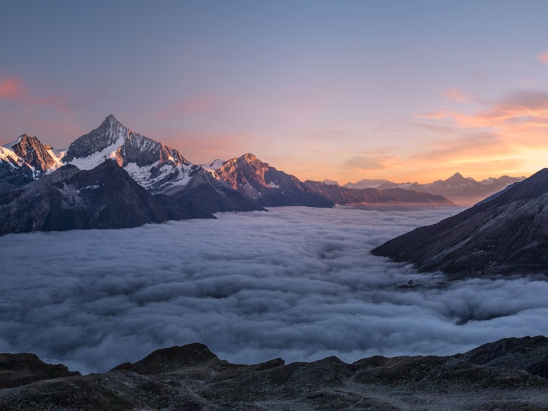
The Tibesti Mountains are a volcanic massif in the deep Sahara of northern Chad, stretching roughly 480 kilometers along the Chad-Libya border. This is not an incremental landscape. The terrain shifts from flat, featureless desert to jagged peaks, collapsed calderas, and blackened lava fields with an abruptness that is difficult to prepare for mentally, even with photographs.
Emi Koussi, at 3,415 meters, is the highest point in the entire Sahara and the highest peak in Chad. Its caldera spans roughly 12 kilometers across — a collapsed volcanic summit that contains smaller craters within it. To the northwest, Toussidé (3,265m) is considered a potentially active volcano, with fumaroles still venting sulfurous gases from its flanks.
Between and around these peaks lie ancient rock art sites — engravings and paintings from periods when this region received significantly more rainfall and supported populations that hunted, herded, and recorded their world on stone. The contrast between the current hyper-arid environment and the evidence of a wetter past is one of the most striking aspects of any Tibesti expedition.

There is no casual way to reach the Tibesti Mountains. There are no roads in any conventional sense, no fuel stations, no lodges, no phone signal, and no emergency services. The nearest significant town, Faya-Largeau, is itself a remote desert outpost hundreds of kilometers to the south.
Permits are mandatory. Travel to the Tibesti region requires authorization obtained in N'Djamena, and the process can take days or weeks. Military checkpoints control access to the area. The region has experienced intermittent conflict, and security conditions can change. Any reputable operator will handle permit logistics, but travelers must understand that access is never guaranteed.
This is not designed to discourage. It is designed to be clear. The Tibesti rewards those who approach it with full preparation, appropriate humility, and the right team. It does not forgive those who underestimate it.
The Tibesti Mountains are the ancestral homeland of the Toubou people (also written Tubu or Teda), one of the most resilient communities on Earth. The Toubou have inhabited this volcanic desert mountain range for centuries, developing knowledge systems, survival strategies, and cultural practices specifically adapted to one of the most extreme environments anywhere.
The Toubou are historically semi-nomadic, moving between mountain settlements and desert plains according to season, water availability, and grazing patterns. Their knowledge of the Tibesti — its water sources, its passes, its weather patterns — is unmatched and cannot be replicated by GPS or satellite imagery. Many expedition operators in the region rely on Toubou guides whose understanding of the terrain has been developed across generations.
“The Toubou do not live in the Tibesti despite its difficulty. They live there because they understand it. That understanding is not available for purchase — it must be respected.”
Travelers who reach the Tibesti should approach Toubou communities with the same respect they would bring to any encounter with people whose home they are visiting. Photography requires permission. Questions should be asked through guides who have existing relationships. The Toubou are not a spectacle — they are the people of this place, and their presence predates any concept of tourism by centuries.
A Tibesti expedition is measured in weeks, not days. Here is what the commitment involves.
A minimum of two 4x4 vehicles is standard practice. If one breaks down in the Tibesti, there is no roadside assistance. Redundancy is survival, not luxury. Most operators run three or more vehicles per expedition.
There are no fuel stations in the Tibesti. All fuel must be carried from Faya-Largeau or pre-positioned at cache points along the route. Fuel calculations determine itinerary length and must account for soft sand, altitude, and detours.
There is no mobile phone coverage in the Tibesti. A satellite phone is not optional — it is the only means of emergency communication. Satellite messengers (InReach or similar) provide tracking and SOS capability.
A typical Tibesti expedition takes two to four weeks from N'Djamena and back. Travel days to and from the mountains account for a significant portion of the total time. There are no shortcuts.
All drinking water must be carried or sourced from known springs with local guidance. Dehydration in the Tibesti can become life-threatening within hours. Water planning is the single most critical logistics consideration.
The nearest hospital is in Faya-Largeau, and its capacity is limited. Expedition teams must carry comprehensive medical kits and ideally include someone with wilderness first-aid training. Evacuation could take days.
The Tibesti is a volcanic province — one of the few major volcanic regions in the Sahara. The range formed through hotspot volcanism, and while the most recent eruptions are estimated to have occurred in the Holocene (within the last several thousand years), geothermal activity continues. Hot springs, fumaroles, and deposits of volcanic minerals are found throughout the range.
The calderas are among the most geologically significant features. Emi Koussi's summit caldera, Trou au Natron (a nested caldera within the range), and several smaller collapse structures provide windows into the volcanic history of the region. Trou au Natron is particularly striking — a deep depression filled with natron (sodium carbonate) deposits that give it an otherworldly, mineral-encrusted appearance.
The ancient rock art found across the Tibesti constitutes an archaeological record of extraordinary value. Engravings depicting cattle, giraffes, elephants, and human figures point to a period roughly 5,000 to 8,000 years ago when the Sahara was significantly greener. These sites are fragile, unguarded, and irreplaceable. Responsible expeditions treat them with absolute care.
This is not a suggested packing list. These are non-negotiable requirements for any Tibesti expedition. Missing any single item can compromise the entire trip.

Chad spans five major ecological zones. Each demands different preparation, different respect, and different understanding.
The Tibesti demands more preparation than any other zone in Chad. Start with geographic orientation, assess your readiness, then begin expedition planning with a qualified operator.


